

Are people in your community being vigilant about the social distance measures we’re being asked to practice?
If you just peer out your windows or walk around your neighborhood, it’s hard to get an accurate gauge. Perhaps that close group of people you see is a family who lives together getting some fresh air, or maybe they’re friends rebelliously gathering in public. The two guys you saw smoking off the same joint and then shaking hands with a random person on the street (true story) could be indicators of widespread ignorance, or they may just be a few fluke fools.
Unfortunately, it will be weeks before we can determine by infection numbers how well our social distancing measures have worked. But in the meantime, we have data that can give us an idea of how well people are following the directives to stay home and away from other people as much as possible.
Unacast is a company that uses smartphone GPS and mapping tools to track human activity for various data usage. (The founders originally wanted to find out where people went to concerts so they could create a better user experience for their music-streaming service in Norway.) And thanks to the ubiquity of cell phones with GPS and no one reading the fine print on where that information goes, they’ve created a tool to track whether or not people are socially distancing the way they should be.
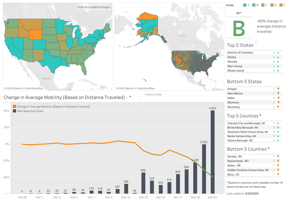
To simplify the data, they’ve created an interactive map that’s updated daily called the Covid-19 Social Distancing Scoreboard. According to how people’s movement changes, they give each state and county a letter grade to let people know how social distance measures are being followed.
The county-specific information is helpful, especially in large states. My state gets a nice solid B, for example, but my county gets a big old F. Lovely.
Unacast.com
One thing that keeps coming up in the fight against the coronavirus pandemic is the need for data. Who has the virus? Where are they located? How long have they been contagious? Who have they been in contact with?
Without data, we are flying blind. And though social distancing is just one piece of the puzzle, having a data-driven picture of where people are practicing it and where people aren’t can help us know where we need to get the word out and perhaps even where to look for potential hot spots in the near future.
Click here to access the interactive map and see how social distancing is going in your community.